In the face of escalating bushfires in Isiolo County, the International Centre for Humanitarian Affairs (ICHA) deployed drone technology to enhance response efforts, demonstrating the growing role of aerial support in disaster management. Over a three-day mission, two drone pilots covered key sites—Bassa, Biliqi, and Sericho—providing real-time intelligence that shaped firefighting strategies on the ground.
Why Drones? Enhancing Humanitarian Response
Wildfires pose a significant challenge due to their unpredictable spread, remote locations, and the difficulty of accessing affected areas. Traditional response methods often rely on ground teams with limited visibility, making it harder to assess the full scale of destruction and allocate resources efficiently. The use of drones bridge this gap by offering:
• Rapid situational awareness: High-resolution aerial imagery and thermal sensors pinpoint active hotspots and track fire progression.
• Informed decision-making: Real-time data allows responders to focus efforts where theyare most needed.
• Access to hard-to-reach areas: Aerial surveillance overcomes the limitations of rough terrain and remote locations.
• Improved safety: Reducing the need for first responders to enter hazardous areas without prior assessment.
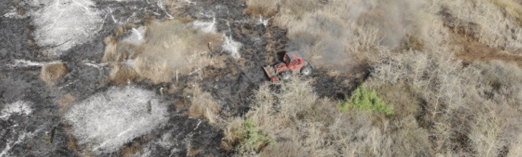
Critical Insights from the Field
At Bassa, drone-assisted thermal imaging revealed embers and smoldering logs, signaling a risk of reignition despite the fire being largely contained. This data guided the Kenya Forest Service (KFS) and other response teams inreinforcing firebreaks and strategically deploying water resources.
In Biliqi and Sericho, extensive pasture loss was confirmed, posing long-term challenges for local herders. While no active fires were detected, drones conducted a Burn Area Index (BAI) analysis, verifying the destruction of grazing lands. This information is crucial for planning recovery efforts, including pasture restoration and livestock support
Overcoming Challenges with Technology
The deployment was not without hurdles—rugged terrain, remote locations, and limited internet connectivity made data transmission difficult. However, drones provided a vital advantage, delivering real-time intelligence that would have otherwise taken days to gather through conventional means.
A Game-Changer for Humanitarian Action
ICHA’s deployment of drones in Isiolo underscores the necessity of integrating advanced technology into
humanitarian response. By enhancing coordination, improving response time, and minimizing risks to responders, drones are proving to be an indispensable tool in disaster management. As climate-related emergencies become more frequent, investments in aerial support will be crucial for building resilience and safeguarding communities.